Borders and geography of Lake Garda
Everything you need to know about the extent, morphology and territorial division of Lake Garda.

The Lake Garda, also known by its ancient name Benaco, is one of the most fascinating geographical, historical and cultural areas in northern Italy. Located between the regions of Lombardy, Veneto and Trentino-Alto Adige, Lake Garda is the largest lake in Italy, with an area of approximately 368 km2 and a length of over 50 kilometres.
Its geographical position, between the Alps and the Po Valley, has made it a crossroads of peoples, cultures and trade over the centuries. The etymology of the name Benaco probably comes from the Celtic term "bennacus", meaning "horned", in reference to the numerous promontories that characterise its perimeter. The name Garda, on the other hand, became established in medieval times and has Germanic origins, coming from the Lombard word "warda", meaning "place of guard" or observation, linked to the town of the same name on the Veronese shore.
The Regions and Provinces of Lake Garda
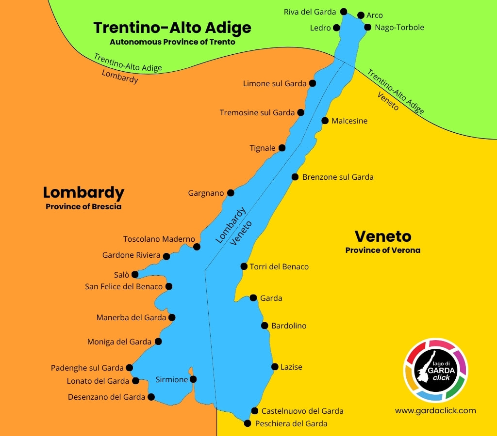
Lake Garda is located in northern Italy and borders with three regions: Lombardy, Veneto and Trentino-Alto Adige. The provinces are Brescia, Verona and Trento, respectively. This administrative peculiarity makes promoting tourism in the Garda area rather complex, as its shores are divided between different regional entities, each with its own traditions, dialects and landscape features.
Lombardy Region
(Province of Brescia) - Western and south-western shore
Veneto Region
(Province of Verona) - Eastern and south-eastern shore
Trentino-Alto Adige Region
(Autonomous Province of Trento) - Northern shore
The municipalities of Lake Garda
Along the perimeter of Lake Garda, there are 26 municipalities that directly border the lake; of these municipalities, 14 are in the Province of Brescia, 8 in the Province of Verona and 4 in the Autonomous Province of Trento.
Municipalities of Lake Garda in the Province of Brescia:
- Desenzano del Garda
- Gardone Riviera
- Gargnano
- Limone sul Garda
- Lonato del Garda
- Manerba del Garda
- Moniga del Garda
- Padenghe sul Garda
- Salò
- San Felice del Benaco
- Sirmione
- Tignale
- Toscolano Maderno
- Tremosine sul Garda
Municipalities of Lake Garda in the Province of Verona:
- Bardolino
- Brenzone sul Garda
- Castelnuovo del Garda
- Garda
- Lazise
- Malcesine
- Peschiera del Garda
- Torri del Benaco
Municipalities of Lake Garda in the Autonomous Province of Trento:
- Arco
- Ledro
- Nago-Torbole
- Riva del Garda
Extent, morphology and origins of Lake Garda
Lake Garda stands out for its impressive size: with an area of approximately 368 km2, a length of 52 km and a width of 16.7 km in the southern part, it is the largest lake in Italy. The coastline stretches for approximately 158 km, while the volume of water is estimated at around 49 km3. The average water level is 65 metres above sea level, with seasonal variations generally ranging between 1 and 1.5 metres.
The maximum depth reaches 346 metres, located between Tignale and Castelletto, while the average depth is around 133 metres. The bottom of the lake has a complex morphology, with an underwater ridge that extends from the Sirmione peninsula to Punta San Vigilio, dividing the basin into two areas: an eastern area, which is shallower, and a western area, which is deeper.
Lake Garda origins are glacial: the basin was formed during the great Quaternary glaciations, particularly during the Würm glaciation (110,000 - 11,700 years ago), when a glacial tongue, coming from the Sarca valley and the upper Adige valley, carved out the depression now occupied by the lake. The debris carried by the glacier gave rise to the morainic amphitheatre that surrounds the southern part of the lake, which is characterised by rolling hills and fertile soil.
Some geomorphological studies have shown that, at the end of the last glaciation, the lake level was at least 30 metres higher than it is today, before gradually lowering until stabilising over the last few millennia.
Hydrography of Lake Garda
The main tributary of Lake Garda is the Sarca River, which flows into the lake between Torbole and Riva del Garda, carrying water from the Adamello and Brenta glaciers. In addition to the Sarca, the lake receives water from numerous smaller streams, including the Ponale (fed by Lake Ledro), the Varone, the Campione, the Toscolano and the Aril, the latter known as the shortest river in Italy with its 175 metres in length.
The only emissary of the lake is the Mincio River, which flows out of the lake at Peschiera del Garda and heads south, crossing Mantua before flowing into the Po River. The Lake Garda water system is heavily regulated by humans through a number of dams and canals that control both the inflow (e.g. the Adige-Garda tunnel, used in the event of exceptional flooding) and the outflow of water, in particular through the Salionze lock on the Mincio.
Water level and temperature of Lake Garda
The level of Lake Garda is subject to natural fluctuations due to rainfall, inflows from tributaries and meteorological phenomena, but it is also artificially regulated for hydroelectric, irrigation and flood protection purposes. The average annual level over the last thirty years has been around 94.7 metres above the hydrometric reference zero.
The surface water temperature ranges from a minimum of 6°C in winter to a maximum of 27°C in summer, with an annual average of around 12°C. At a depth of 100 metres, the temperature drops to around 8°C. These conditions, combined with the large mass of water, help to moderate the climate of the entire surrounding area.
The climate and winds of Lake Garda
Lake Garda has a sub-Mediterranean climate, unique among the large Alpine lakes, thanks to the mitigating effect of the water mass and the protection offered by the surrounding mountains. Temperatures are generally moderate, with mild winters and warm but breezy summers. Rainfall is well distributed throughout the year, with relatively little precipitation in winter and thunderstorms in summer.
Lake Garda is also renowned for its winds, which influence the climate and sporting activities, particularly those related to sailing and water sports.
The main winds blowing on Lake Garda are:
Pelèr
North wind blowing in the early morning until midday, particularly intense in the upper and middle lake areas.
Ora
South wind blowing in the early afternoon until sunset, particularly present in the upper and middle lake areas.
Ander
South-west wind blowing in the early afternoon, mainly affecting the lower lake area.
Balì
A predominantly winter wind that blows strongly after snowfall or a sharp drop in temperature.
Vinessa
A very strong wind that can blow from the east following disturbances in the upper Adriatic area.
The landscape of Lake Garda
To the north, Lake Garda narrows into an alpine basin that creeps between rocky walls. Famous tourist destinations such as Riva del Garda and Torbole are located in this area. The characteristics of the territory give colder waters and a more continental climate with mountain forests that descend to low altitudes and rugged landscapes where the contrast between the lake and the mountains is truly spectacular.
To the south, Lake Garda opens up into a large morainic basin, characterised by gentle shores, pebble beaches and an agricultural landscape dotted with olive groves and vineyards. This is the most Mediterranean part of the lake, ideal for beach tourism, cycling and food and wine experiences. The Sirmione peninsula, about 4 km long, clearly marks the geography of the lower lake. It is a very popular place among tourists for its clear waters and thermal springs.
To the east, Lake Garda is dominated by the majestic ridge of Monte Baldo, which stands parallel to its shore and reaches an altitude of 2,218 metres. Towns such as Malcesine, Brenzone and Torri del Benaco are nestled on its slopes, and the Malcesine cable car allows you to quickly travel from the shores of the lake to the large high-altitude meadows. Here, the steep gradient creates a unique microclimate and exceptional biodiversity, with high-altitude grasslands, beech forests and typical alpine environments.
To the west, Lake Garda changes considerably, passing from the hills of Valtenesi to the mountainous area of the Alto Garda Bresciano Park. Here, the landscape is characterised by peaks such as Monte Pizzocolo, which dominates the area at 1,581 metres, offering an extraordinary view of the lake. The transition in altitude from Valtenesi to the beech woods of the park creates a landscape rich in contrasts, ideal for both easy walks and more difficult hikes.
The 5 islands of Lake Garda
Isola del Garda (San Felice del Benaco)
It is the largest island in the lake and home to the spectacular Villa Borghese Cavazza. Today it is a popular tourist destination, open to visitors on guided tours and available for exclusive events and weddings.
Isola di San Biagio (Manerba del Garda)
Located a short distance from Punta Belvedere, the island can be reached on foot when the tide is low. Privately owned and accessible for a fee, it has a bar and areas equipped for relaxation.
Isola dell'Olivo (Malcesine)
This small island is covered with wild vegetation and is located just 200 metres from the coast. It is very popular with diving enthusiasts due to the presence of an underwater cave at a depth of about 13 metres.
Isola del Sogno (Malcesine)
Located a few metres from the coast, this small island can be reached on foot when the tide is low. Covered in wild vegetation, it is known among divers for a 16-metre-long wreck located at a depth of about 30 metres.
Isola di Trimelone (Brenzone sul Garda)
After the Second World War, the island became an explosives depot, until the tragic explosion of 1954 that devastated its surface. Recently reclaimed by the Italian army, the island still has some military buildings visible from the coast.
Explore Lake Garda
More interesting facts await you, discover them below!